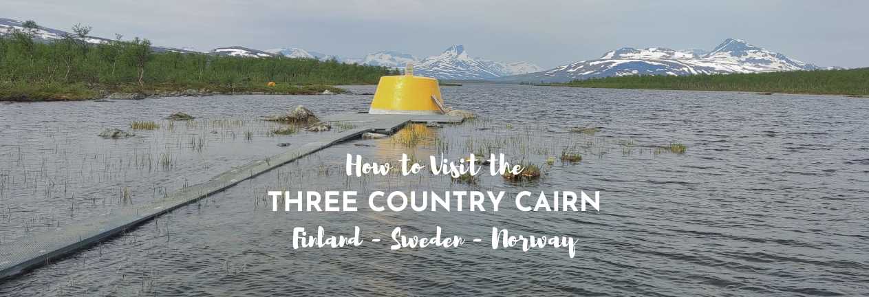
The Three Country Cairn is where the borders of Finland, Sweden, and Norway meet. This type of point on the map is known as a tripoint and there are 175 of them around the world, but this one is special, it’s the world’s most northerly tripoint. This tripoint, marked by the Nordic three-country cairn was on the route of our Nordic Road Trip, so we couldn’t resist visiting. It turns out that there are several ways to get to the three country cairn and to visit the Sweden, Norway, Finland border. I’ve detailed how you do that, and explained why and how we visited from Finland. Here’s our guide to the three country cairn boat trip and hike.
THIS POST MAY CONTAIN COMPENSATED AND AFFILIATE LINKS MORE INFORMATION IN OUR DISCLAIMER
Our Nordic Road Trip continues – we drove north from Helsinki, and had a glorious time in Koli National Park before heading for our bear watching adventure, after a quick stop at the Arctic Circle (that makes me shiver, knowing that from now on we’re above the Arctic Circle!) and then it was back over into Sweden and it’s most northerly city of Kiruna for an amazing LKAB mine tour. And now we’re back in Finland, and heading towards where the Sweden, Norway, and Finland borders meet, at the world’s most northerly three country cairn.

What is the Three Country Cairn?
The world’s most northerly tripoint – where the borders of Finland, Sweden, and Norway meet is at 69° North and is 490 meters (1607 feet) above sea level. There is another tripoint relatively close – where the borders of Norway, Russia, and Finland meet, but it is 900 meters (2952 feet) further south than this three country cairn, and the borders are strictly guarded, so if you want to run freely around the borders you’ll need to come to this three country cairn where Finland, Sweden, and Norway meet.
PRACTICAL TRAVEL TIPS
- 🛡️ Get Travel Insurance: Civitatis includes medical expenses, repatriation, theft, luggage delays. No deductibles or upfront payments. Get a quote here.
- 🛏️ Sea view? Laundry? Private bath? Book a Room.
- 🔌 Be ready for the plug, socket & power situation.
- 📶 Internet, maps and data on the go. eSims for Travel
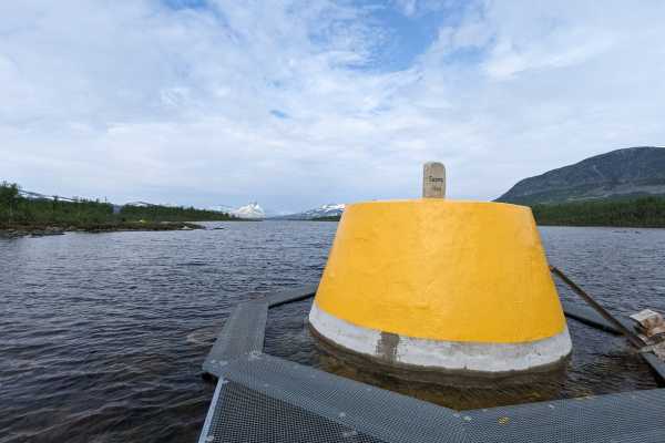
The first cairn here was built in 1897 when the Russians and Norwegians built a cairn. Sweden, however, wasn’t involved, as Norway and Sweden were in disagreement about the border. Roll forward to 1901 and Norway and Sweden were in agreement so a border cairn was created, and encased in cement, but poor construction and shifting ice meant that it eroded significantly because of the winter weather conditions. The current cairn dates from 1926, and it marks the borders between Norway, Sweden, and Finland. Finland having gained their independence in 1917.
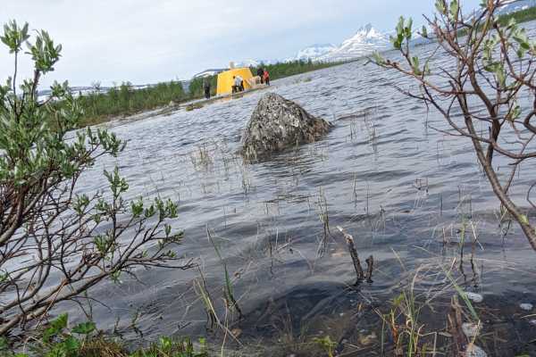
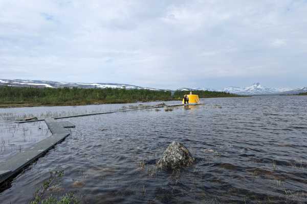
The cairn is a yellow-painted concrete structure, it’s built about 10 meters (33 feet) into Lake Goldajärvi. The cairn is 14 square meters in diameter and 4 meters (13 feet) high. There is a boardwalk that you take to reach it. (Although depending on the level of the meltwater, you might get wet feet!)
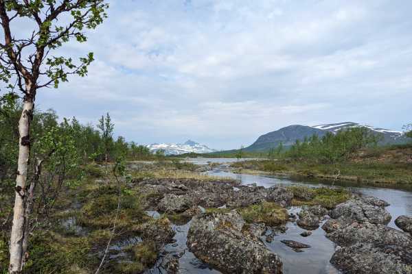
Lake Goldajärvi (which lies within Norway) is known as Koltajärvi in Finnish, Golddajávri in Sami, Koltajaure in Sweden, and Golddajávri Lake in Norweigan. It is a rare type of lake known as a bifurcation lake. Bifurcation means that it drains to more than one place – the water flows to both Lake Kilpisjärvi and the Norwegian Sea via the Lyngen Fjord from Lake Goldajärvi.
- In Finnish, the three country cairn is Kolmen valtakunnan rajapyykki
- In Northern Sami, the three country cairn is Golmma riikka urna
- In Norweigan the three country cairn is Treriksrøysa
- In Swedish the three country cairn is Treriksröset.
Practical Considerations for Visiting the Three Country Cairn
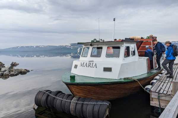
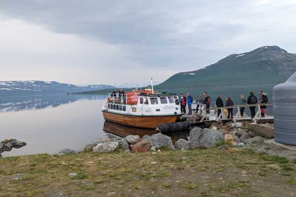
I’ve detailed how to get to the three country cairn from each of the three countries, but the easiest (and most popular way) is to start your journey from Kilpisjärvi in Finland. If you’re traveling in the summer months, then take the M/S Malla boat (more details on that soon), either both ways or hike back.
Where is the Three Country Cairn?
The closest village to the three country cairn is Kilpisjärvi in Finland. The cairn is an 11 kilometer (6.83 mile) hike from a parking lot 8 kilometers (5 miles) north of the village off the side of the E8 international road that leads from Finland to Norway. The hike goes through the Malla Strict Nature Reserve. The cairn is found at 69° North.
How to Get to the Three Country Cairn
You’ll need to make your way to Kilpisjärvi in Finland to start your trip to the three country cairn. And remember if you’re coming from Sweden or Norway that Finland time is ONE HOUR AHEAD of both countries.
If you’re coming from Sweden, you’re likely coming from Kiruna (like we did after the fabulous LKAB mine tour). It’s a four hour drive from Kiruna to the east – but don’t forget you’ll lose one hour in the time difference as you cross the border into Finland.
If you’re traveling on public transport, then you’ll need to take the bus from Kiruna to Karesuando. This bus takes about 3 hours and you’ll have to overnight in Karesuando, before walking the 1 kilometer (0.62miles) to Finnish Karesuvanto. From Karesuvanto you’ll need to take a bus to Kilpisjärvi, which will take about 90 minutes.
Where to Stay to Visit the Three Country Cairn
The closest place to stay to visit the three country cairn is in the village of Kilpisjärvi. There is very limited accommodation in this village of about 100 permanent residents, so you’d be advised to book accommodation early or be prepared to drive further.
Boat Trip to the Three Country Cairn
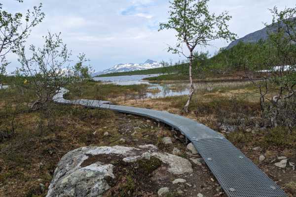
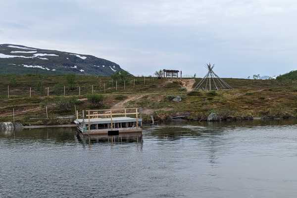
The easiest way to visit the three country cairn in the summer months is to take the boat trip from Kilpisjärvi in Finland. The boat, the M/S Malla (or the Maria on the day we took it) takes about 45 minutes to go from Kilpisjärvi to the dock or harbor called Koltalahti/Koltaluokta, which is an old Sami settlement. From there it’s a 3 kilometer hike to the three country cairn. The path is well marked, but some parts of it may be underwater depending on the water levels at the time.
The boat waits for around 2 hours and then returns to Kilpisjärvi. Note that the boat only runs from mid-summer until the end of September, they publish their open and close dates here.
Buying tickets for the M/S Malla to the Three Country Cairn
Tickets for the boat can only be bought on board the boat, and there are no reservations, it’s first come first served, although the boat can take 130 passengers.
Ticket cost for the M/S Malla to the Three Country Cairn
A one-way ticket costs 40€ per adult and 10€ for children under 16. Return tickets are 55€ per adult and 10€ per child. (note these are 2023 prices, I’ll update when the new prices come out for 2024). Cellphone signal is VERY spotty out there. Especially after the boat starts to move, so card payments may not go through. Take cash.
Departure Times for the M/S Malla to the Three Country Cairn
There are usually two departures a day, one at around 10:00 and another at 14:00. Check here for current times.
Hiking one way, taking the boat the other
You can take the boat one way, and then hike back through the Malla Strict Nature Reserve. This trail is 11 kilometers (6.83 miles) and ends at the parking lot 8 kilometers (5 miles) north of the Kilpisjärvi village. You can also hike to the three country cairn and then take the boat back to Kilpisjärvi. However, if you do this you MUST reserve a place on the boat by calling +358408485494. If you don’t and there are no passengers leaving from Kilpisjärvi, then the boat will NOT run (and you’ll be walking both ways whether you like it or not!)
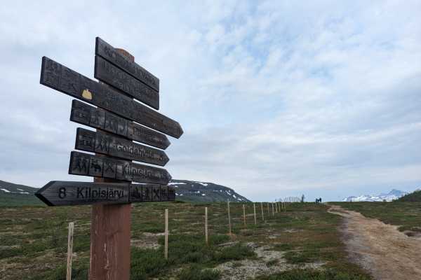
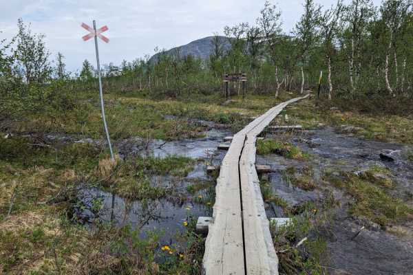
If you’re hiking through the Malla Strict Nature Reserve, then you are required to stick to the trail which is marked with black orange headed wooden posts.
Visit the Three Country Cairn from Finland
The shortest and easiest way to get to the three country cairn is from the small Sami village of Kilpisjärvi in Finland. During the summer months take the M/S Malla from the dock in Kilpisjärvi and then hike for about 20-30 minutes along a well-marked path to the three country cairn. You can always take the boat one way and return by the 11 kilometer (6.83 mile) hiking trail.
Alternatively, if you wish to hike both ways (22 kilometers – 13.67 miles), then you’ll want to start on the E8 road, just after the border (i.e. in Norway), and follow the trail. The trail is well marked, and it’s relatively flat, but it can (and usually is) challenging. The ground underfoot, especially in early summer is likely to be wet. Depending on how much the ice has melted, you’d be wise to wear good waterproof socks, and good boots and ensure that you have poles, as they might help with sudden holes and waterlogged paths. (my guide to hiking poles is here)
Hike to the Three Country Cairn from Norway
There are two ways that you can approach the three country cairn from Norway, I’ll start with the easiest, and that’s from the parking lot on the E8 road which runs north to south between Norway and Finland.
After we’d returned from the three country cairn and started our drive towards Tromso in Norway, we passed the parking lot for approaching the three country cairn from Norway. It’s on the E8 road (I’ve marked it on the map for you). If you’re coming from Finland on the road, then cross the border, and park in the large lot – it’s about 8 kilometers (5 miles) from Kilpisjärvi in Finland.
The longer route to the cairn from Norway starts from Signaldalen in Storfjord. It’s about 30 kilometers (18.64 miles) one way, and you’ll need to stay overnight at one or more of the Den Norske Turistforening (DNT) cabins (they’re called Gappohytta and Goldahytta). The cabins are unmanned and you’ll need to take all your own sleeping and eating equipment. The Goldahytta cabin is 2.5 kilometers (1.55 miles) from the three country cairn. There’s more here on the DNT cabins and the detail on hiking from Signaldalen is here.
Visit the Three Country Cairn from Sweden
This is the toughest way to approach the three country cairn – and it’s going to involve at least a 70 kilometer (43 mile) one way hike, that includes several river crossings. You can do this as part of the Nordkalott Trail. This 800 kilometer (497 mile) trail tracks the Norway, Sweden, and Finland borders, and there are some cabins along the way, but a tent is also advised. As well as a guide. And decent gear. You can read more about the Nordkalott Trail here. And you’ll find more specific details on the huts and trail maps here.
Our Visit to the Sweden Norway Finland Border – the Three Country Cairn
After our LKAB mine tour in Kiruna, Sweden, we left Sweden and crossed the border back into Finland (losing an hour with the time difference) and headed towards our Finnish accommodation, where we’d check in, eat, sleep and get up to head towards Kilpisjärvi in the morning to hopefully catch the M/S Malla / Maria towards the three country cairn.

We’d been in communication with the team who run the boat for several days, as we were traveling very early in the season, so it was touch and go as to whether the ice would have broken up enough for the boat to run. Luckily for us, it was.
As we’d seen in Koli National Park, the mosquitoes were out something fierce, so we didn’t fancy an 11 kilometer hike there (or back) to the cairn, even though we were carrying all sorts of anti-mosquito defenses, like spray, long-sleeves tucked in, socks tucked into trousers and head nets too!
We arrived at the boat dock in Kilpisjärvi about 15 minutes before departure time and there was a line. It looked like there would be plenty of room, though, (and there was). However, we did have a pretty full boat on our trip, which was on 21 June, just a few days after the first trip of the season.
You can pay the fees (55 euro return) by card or cash, but the boat will set off as soon as everyone is boarded, and they will continue taking payments after they’ve set off, so the card machine tends not to work when you get away from the dock. It’s best to have cash as a backup.
We sat up top one way, and down below the other. The views are pretty spectacular whichever way you look, although the breeze was a little chilly up top. The boat takes 30-45 minutes and you’ll arrive at the old Sami settlement of Koltalahti, where there’s a proper dock.
Unless you’ve done this hike before you’re going to get a briefing from the boat crew so that you know which way to go (it’s really hard to get lost), and most importantly, if you’re taking the boat back, what time the boat leaves. The boat usually does two trips per day, so it needs to get back on time after this first trip, to ensure that the rest of the day runs on time.
And after that, with us all taking a photo of the map (not that we actually needed it), we set off.
While it felt that there were a lot of us on the boat, we quickly strung out and were able to walk at our own pace, without standing on other people’s heels.
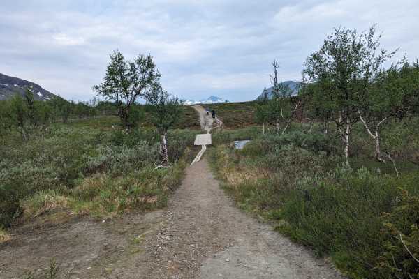
The trail is well-made, primarily sandy, although there was some mud.
In areas of the trail where there’s water, there are boardwalks, although some of these were underwater.
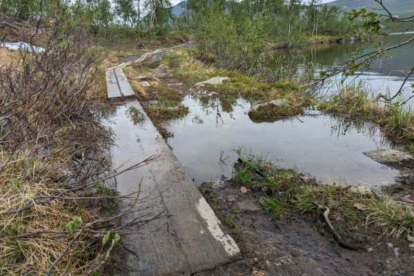
I wore my Sealskinz waterproof socks as my hiking shoes are only waterproof to a certain extent (mainly for rain, not for walking through ankle-deep puddles. And I was glad I did, dry feet for the win!).
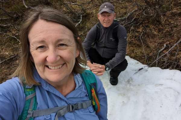
We even found a small patch of snow off the side of the trail too.
It’s a 3 kilometer (1.86 mile) walk from where the boat docks to the three country cairn. And it’s so lovely and pretty. We didn’t need our mosquito head nets on the way there, we just kept walking at a decent pace and when we arrived at the lake the breeze off the water was enough to keep them away too.
The cairn on the lake with the snow-topped mountains in the background is ridiculously photogenic. And yes, we did run around the cairn quickly, just to say we’d been in all three countries within 10 seconds.
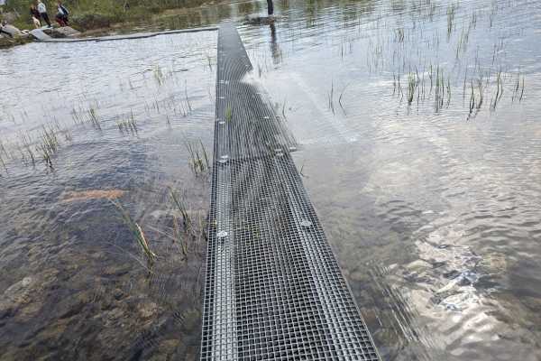
The metal pathway out to the cairn was partially underwater, and yes the lake water was particularly cold but gloriously clear!
Objective achieved, we found ourselves a comfortable rock for our lunchtime picnic. You’ll definitely want to bring snacks or a lunch picnic and also the water that you want to drink. The boat crew was clear that they believed that the water was safe to drink, but you did so at your own risk. Our filter water bottles once again came into their own. Just to be sure!
And of course, after lunch, there was a 3 kilometer (1.86 mile) trail to take back to the boat. There’s plenty of time to walk the round trip in the allocated time of 2 hours and get onto the boat for the trip back across the lake to Kilpisjärvi, where our final view of the village was of one of the full-time residents, taking a low wander down the road.
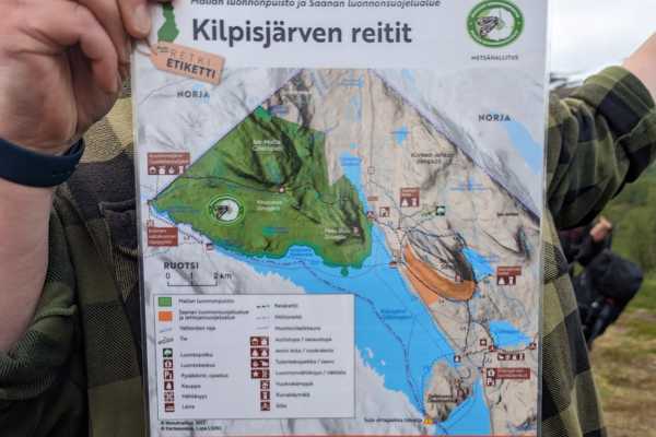
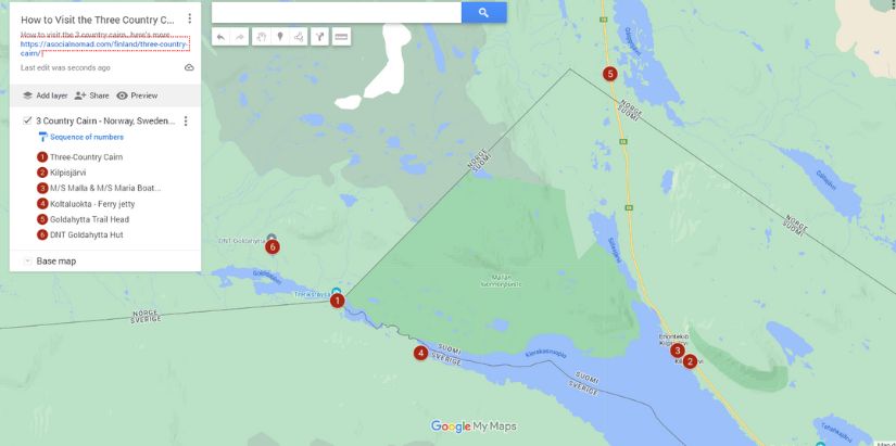
Map of How to Visit the 3 Countries Cairn
You can see the full map for the Finland, Norway and Sweden 3 Country Cairn here.
Travel Tips for Finland
- Get Travel Insurance: Civitatis includes medical expenses, repatriation, theft, luggage delays. No deductibles or upfront payments. Get a quote here.
- Get online NOW with an eSIM for Finland
- Rent a car to explore Finland with Discover Cars
- Get your Finnish airport transfer here with Welcome Pickups.
- Book the best tours, attractions and guides on Get Your Guide and Viator
- Save money in Finland with a Wise debit card
- Book accommodation in Finland with Booking
Final Words on Visiting the Three Country Cairn
When we were putting together our Nordic Road Trip we were looking for things that were a little out of the ordinary and also very representative of the countries that we were going to. And being able to visit three different countries within the space of 10 seconds after taking a boat trip across a lake where the ice has only just broken up, and then hiking. And doing all of this above the Arctic Circle. Yeah, that ticked the boxes. This is a fabulous place to visit, make the three country cairn a destination of yours in the future!
ASocialNomad is a participant in the Amazon Services LLC Associates Program, an affiliate advertising program designed to provide a means for sites to earn advertising fees by advertising and linking to amazon.com, amazon.co.uk, and amazon.ca. Amazon and the Amazon logo are trademarks of Amazon.com, Inc. or its affiliates. As an Amazon Associate, I earn from qualifying purchases.
2 thoughts on “The Three Country Cairn at the Sweden, Norway, Finland Border”
Hello. Can we go to the Three-Country-Cairn in early November? We plan to do it coming from Finland.
Thank you
You should be able to get there on skis, the boat season ends at the end of September and the water will be iced over, I would check with https://www.facebook.com/mallalaiva – while the boat doesn’t run, they will know the best way to get there in the winter months (there are several trails, and one might be better than another in the winter). Sarah