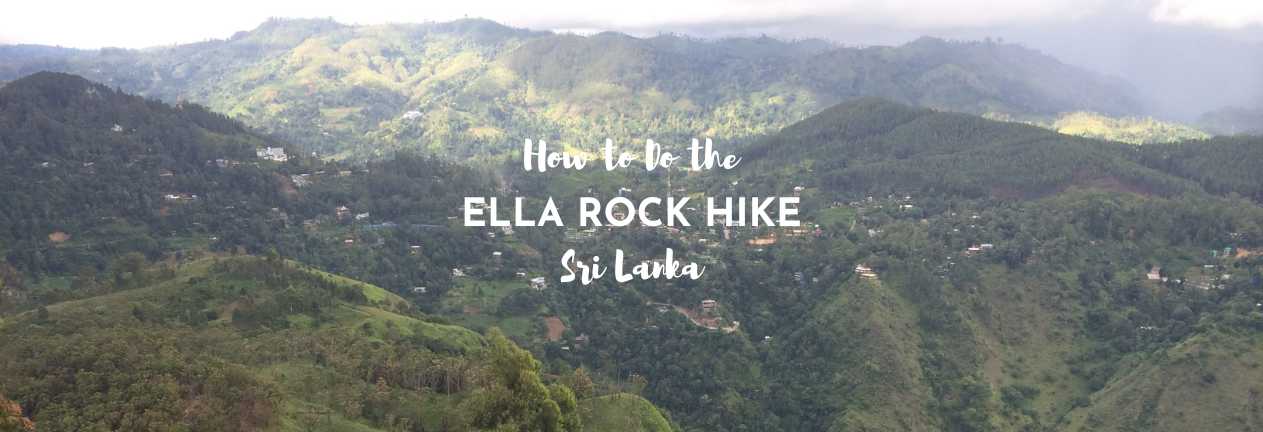
We’ve spent considerable time in Ella Sri Lanka, on both of our month-long trips to this tear-drop-shaped island in the Indian Ocean. And the town has changed a lot. Even on our first visit, the main street was busy, not the promised quiet hill country we were expecting. However, you don’t have to get far out of the town to see the glorious countryside that Sri Lanka’s Hill Country promises. Ella is a great place to head out for a hike, and the most challenging of these is the Ella Rock Hike. Here’s our guide to getting to Ella Rock, and what you can expect.
THIS POST MAY CONTAIN COMPENSATED AND AFFILIATE LINKS MORE INFORMATION IN OUR DISCLAIMER
One of the good things about hiking in Ella is that you’re at a little bit of altitude, and so it’s a little cooler. Ella’s location in Sri Lankan’s Hilly Country is at an altitude of 1,041 metres (3,415 feet) and the weather up here tends to follow a pattern of having sunshine in the morning and cloud and possibly rain later in the day. And so all the hikes that we’ve done in Sri Lanka have followed the same pattern, get up early, hike, and head back before any rain arrives.
GUIDED HIKE TO ELLA ROCK

Take A Guided Hike to Ella Rock
With this door-to-door trip in Ella, you’ll get to see Nine Arch Bridge, hike to Ella Rock, AND hike Little Adam’s Peak too!
The Ella Rock Hike
Ella Rock is a somewhat dramatic peak about 5 kilometers (3 miles) from the center of the town of Ella. It stands over a deep valley leading away from the town. I’ve detailed instructions on how to do this hike in Ella and then included our experience. And yes we did hire a local guide to help us. It’s not expensive, and Sri Lanka hasn’t had the best of times. I figure the small amount that it cost me was better in the hands of the locals
Ella Rock Hike Directions
Here are the step-by-step instructions on getting to Ella Rock from Ella.
- Start the Ella Rock Hike at Ella Railway Station. You’ll need to get onto the platform and turn left. After you reach the end of the platform, get down onto the tracks – ignoring the sign that says you shouldn’t go on the track. And start walking. Bear in mind that these tracks are used. So keep an ear out for trains. They won’t stop for you. You’ll have to jump out of the way of them.
- You’ll walk along the track for about 35-40 minutes, you’ll get to the Kithalella platform (it’s hard to call it a station).

- Walk on past the Kithalella platform for another 7-8 minutes. Unless more turnings have appeared, you’ll want the SECOND left. There may be a rock marked with a blue arrow and “Ella Rock”.
- There are markers on the railway line, and you want the left turn after marker 166 ½. It’s almost like turning back on yourself.
- This path will take you to a footbridge to cross the river.

- After crossing the river, take the left-hand path when it forks. The path to the right also leads up to the top of Ella Rock, but it’s a longer route.
- Head on up through the tea plantation. There may or may not be blue arrows here, and depending on the time of year that you’re hiking Ella Rock, they may be covered over with vegetation. Keep going straight on, and you’ll pass long grass on either side of the track, which brings you the first of the viewpoints. (You’re not there yet!)
- From this first viewpoint, you can continue straight on to the top of Ella Rock
- In 2023 there’s a 900 LKR charge to access the Ella Rock viewpoints. There’s a ticket office and some toilets too.
Our Hike to Ella Rock
We hiked Ella Rock two days after we hiked Adam’s Peak and the calves were really tight, but we were trying to get our hikes in before the rain. And Ella Rock is one of the best hikes in Sri Lanka. The hardest part of hiking Ella Rock in Sri Lanka is actually finding the route. We ended up using a local to help us and put together the instructions above based on this. Our first challenge was believing that we had to walk along the railway track.
“Which way?” we ask the station master. “That way, along the line,” he says. Past the “Walking Along the Track is Prohibited Sign”.

So off we went
No wonder the trains are so rocky, so bouncy when we walk along the tracks and see their general condition. Some of these gaps look as though they’re expecting some serious heat expansion. Some sleepers move as I step on them.

I resolve not to think about what happens when a train goes over them. Some are rotted away and we jump across pools of water.
We jumped out of the way, as with surprisingly little warning, a train appeared rumbling slowly down the hill.

It took us two attempts to figure out where to get off the line and we finally head across the river, and wind around a field of growing vegetables. It’s the local kids, still asking for pens, like they were when we hiked Lipton’s Seat, that directs us. It’s like we’re going through people’s gardens now. Perhaps we are.
We end up in a wooded area where the track just peters out when we spot a local, yelling “Ella Rock?” and looking lost does the trick. He comes up and gestures for us to follow him. The good news is that we wouldn’t have guessed this direction at all. About 10 minutes later, there’s the semblance of a track so we give him a few hundred rupees and thank him, figuring his brother is probably waiting for us in a few hundred meters if it’s really that difficult to figure out where the track is.
Despite all the reviews, we found few signposts and blue arrows – imagining that I’m looking in the wrong place, or that the locals remove them, we’re just glad to be on our way.
It’s a scramble up and down. We’d have been lost without our local assistance. We climb up part of a stream and meet folks coming down with a guide. And then, as we wander out of the trees at the top, we’re there. At the top. Where there is the obligatory sleeping Sri Lankan dog.
And we can see for miles.

One minute. The next, and it takes literally 30 seconds, a mist comes up the valley and the mountain and it’s white.

We can see no further than fifty meters. It’s a magical experience.

We’re passed on the way back down by a Frenchman, who’s decided to run down the hill, which I consider potentially foolish as he hops from rock to rock. Then he points out his guide is barefoot and seriously outrunning him. Fair enough. It reminds me of the Sherpas we trekked to Everest Base Camp with in Nepal.
It was perhaps our best day in Sri Lanka, this trip to the top of Little Adam’s Peak and then to the top of Ella Rock. It was quite simply a lovely day, with glorious views and two pleasant hikes, and on this trip to Sri Lanka, when it rained every single one of the 28 days that we were here, we beat today’s rain back to sit on the covered verandah at the Rock Face hostel.
Key Tips on Hiking Ella Rock
How long does it take to do the Ella Rock Hike?
It’s going to take you about 3 hours to do the round-trip hike from the Ella Railway station to the top of Ella Rock and back. The Ella Rock hike is about 10 kilometers (6 miles) and while it starts on the flat, walking along the railway tracks, they’re not the easiest things to walk along.
What should you wear to hike Ella Rock?
You’ll need decent footwear to do this hike in Sri Lanka. I wouldn’t recommend sandals, even hiking sandals, but proper closed-toed hiking shoes. Take a sun hat, sunglasses, and sun cream.
Do you need Hiking Poles to do the Ella Rock Hike?
I’d recommend hiking poles for hiking Ella Rock. Not necessarily for the way up, but they’d be useful on the way back down.
TOP HIKING POLES PICK
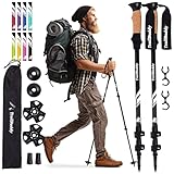
These fabulous budget trekking poles are the best buy and the most popular poles for hiking.
What’s the trail like to Ella Rock?
The trail to Ella Rock starts with a hike along the railway tracks, so it’s pretty flat, but you have to watch, the sleepers aren’t all that solid or even. Once you turn off the railway track, you’ll start heading upwards gradually, and then it will become a lot steeper. There are very rocky scrambling parts of the trail, and if it’s been raining it will be muddy.
If you’re looking for an easy hike, then heading to Horton’s Plain National Park and hiking to World’s End is an easy option. I wrote about it here.
How hard is it to hike Ella Rock?
This is a pretty challenging hike, more because of how difficult it is underfoot, the terrain changes, and there’s quite a lot of scramble involved, but it’s a fun hike to do.
What’s the Best Map to Follow to Hike Ella Rock?
The best map to follow when hiking Ella Rock is alltrails.com. This link will take you to the best options for hiking Ella Rock.
Travel Tips for Exploring Sri Lanka
- Get Travel Insurance: Civitatis includes medical expenses, repatriation, theft, luggage delays. No deductibles or upfront payments. Get a quote here.
- Get online immediately with an eSIM – one SIM for the whole world, data never expires.
- Download and install a VPN BEFORE you travel to Sri Lanka > discount coupon here
- Book your airport transfer with Welcome Pickups
- Read about transport in Sri Lanka in our guide here
- Our guide to booking trains in Sri Lanka
- You will 99% likely need a power adapter for Sri Lanka – there’s more here.
- Book the best Sri Lanka tours and guides on Get Your Guide
- Book Trains in Sri Lanka with 12goAsia
- Book accommodation in Sri Lanka with Booking
Final Words on the Ella Rock Hike
The Ella Rock Hike is a great Sri Lanka hike. You’ll want good weather because, after all, the view is what you’re going up for. We got both a great view and a not-so-great view. You’ll be able to see Little Adam’s Peak from the top and all down the valley. Plan on taking water, and some cash with you to get into the viewpoints at the top.
ASocialNomad is a participant in the Amazon Services LLC Associates Program, an affiliate advertising program designed to provide a means for sites to earn advertising fees by advertising and linking to amazon.com, amazon.co.uk, and amazon.ca. Amazon and the Amazon logo are trademarks of Amazon.com, Inc. or its affiliates. As an Amazon Associate, I earn from qualifying purchases.