
This 250-kilometer (155 mile) circular route has been popular for more than 25 years. Drive it, cycle it, motorbike it, but definitely do it. This is the Finland Archipelago Trail and it means taking a route that includes islands, bridges, and 8 ferries. The trail is open during the late spring, summer, and early fall months and uses the roads that connect the islands that you’ll travel across. It’s a stunning road trip and while we would have loved to have cycled the archipelago trail, the time we’d allocated to our Nordic road trip didn’t allow this for us, and so we were driving the Finland Archipelago trail in a (long) day trip from Turku. And it was glorious. Here’s how to drive the archipelago trail in Finland.
THIS POST MAY CONTAIN COMPENSATED AND AFFILIATE LINKS MORE INFORMATION IN OUR DISCLAIMER
BEST WAY TO TRAVEL
Rent a Car for the Archipelago Trail
By far the easiest way to travel around the archipelago is in your own vehicle. Book a rental car early for the best availability and best prices.
We rented our car for our Nordic Road Trip in Stockholm (actually from Skavsta airport), and after exploring Stockholm in two days we took the absolutely glorious overnight ferry from Stockholm to Turku and, arriving first thing in the morning were ready to tackle the Archipelago Trail.
The Finland Archipelago Trail
The archipelago trail in Finland is a 250 kilometer (155 mile) circular route. It’s a popular cycling route, it’s also popular amongst motorcyclists and drivers. You’ll visit some glorious islands, you’ll actually use bridges and free ferries to travel between them. There’s one ferry that you’ll need to pay for, but it’s worth the cost for this stunning Finnish road trip.
The Finnish Archipelago is the world’s largest archipelago and comprises around 40,000 islets and islands. You won’t get to visit anywhere near that many islands. There is a second trail, called the Small Archipelago Trail, and is just 120 kilometers long, taking 3 ferries and traveling to 15 permanently inhabited islands (and lots of uninhabited ones too), but for this article, we’re focusing on the main Archipelago Trail. There’s more on the small archipelago trail here.
PRACTICAL TRAVEL TIPS
- 🛡️ Get Travel Insurance: Civitatis includes medical expenses, repatriation, theft, luggage delays. No deductibles or upfront payments. Get a quote here.
- 🛏️ Sea view? Laundry? Private bath? Book a Room.
- 🔌 Be ready for the plug, socket & power situation.
- 📶 Get online EASILY & cheaply – One eSim for the world. Data never expires
Where is the Finland Archipelago Trail?
Finland’s Archipelago is located in southwestern Finland, the start (or finish) point of the archipelago trail is in the city of Turku, and the end (or start) point is in Naantali. We started and finished in Turku.
How to Get to the Finnish Archipelago
The closest city to the archipelago trail is Turku, Finland’s oldest City (I wrote about Turku here), and that’s also where the nearest airport and ferry port is to the trail. If you’re flying into Helsinki, then it’s about an hour and 45 minutes to Turku from there. You can rent a car from Helsinki or Turku, as the train from Helsinki to Turku is quick, efficient, and relatively cheap (buy train tickets here.)
We had taken the overnight ferry from Stockholm to Turku and arrived first thing in the morning, which is a key point for catching some of the ferries on the Finland archipelago trail.
Practical Considerations for Driving the Finland Archipelago Trail
Here’s what you’ll need to think about when driving the archipelago trail in Finland.
Rent a car to drive the Finland Archipelago Trail
For a full day driving the Archipelago trail you’ll need a car. The closest place to the trail to rent a car is in Turku. You can get a price for renting a car in Turku here.
Get a SIM Card for Finland
Make sure you download offline maps before you set off, although there is usually a good signal. However, check into getting a local SIM card for your Finnish travels. We use and recommend Surfroam, its a fabulous option that we’ve used for years. One single eSIM (you can get physical SIMs as well if your phone isn’t eSIM enabled), no data packages, just credit and you pay a different rate in each country. It never expires. Perfect if you’re traveling lots. Get a Surfroam eSIM here!.
Prebook accommodation on the Archipelago Trail
Regardless of how long you plan to take to drive the Archipelago trail you’ll need to prebook accommodation. And if you’re driving it in one day, then you’ll need to prebook accommodation at the beginning and end in either Turku or Naantali. Here are our recommendeded places to stay
Turku: In Turku, opt for the Hotel Kakalo. Once Finland’s most notorious prison, its been reinvented as a boutique hotel where you can stay in either a rather nice room, or a rather nice cell! Yes, truly. A cell. You can check rates here.
Naantali: Head to the Hotel Palo in Naantalifor a fabulous stay. The Hotel is in the old town and close to all food and drink options. All rooms have private bathrooms, WiFi and access to the private courtyard. You can reserve a room here.
There are several islands along the way where, if you’re driving for more than one day, it makes sense to stay and explore a little and the best options for accommodation are via Booking here:
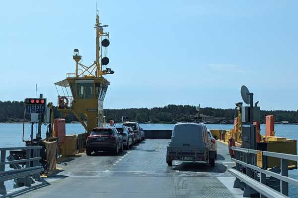
The Ferries of the Archipelago Trail in Finland
There are two types of ferries on the archipelago trail. There are free ferries and there is a single paid-for ferry. The free ferries of the archipelago trail are both yellow and free. They also cannot be booked, you simply turn up and wait for the next one. Some of the ferries have a specific timetable, others are on demand. The longest of these free archipelago ferries takes 30 minutes.
The paid-for ferry is the one that goes from Houtskär to Iniö. This is also a timetabled ferry. This ferry is the primary reason that we chose to drive the Archipelago Trail in an anti-clockwise direction. There are more details on the ferry timetables and costs later in this article.
Should you drive the Finland Archipelago Trial Clockwise or Anti Clockwise?
Many of the guides that you’ll see on the Finland Archipelago trail actually do the trail clockwise. We decided to drive the archipelago trail in an anti-clockwise direction for the primary reason that the Houtskär-Iniö runs only 5 times a day and while we had organized our trip, we were concerned that if we missed a scheduled ferry, or even worse, the last one, then we’d be stuck on the archipelago. And while that is no hardship, as this is a glorious place to get stuck, we’d also pre-booked 90% of our accommodation on our Nordic road trip, and that would seriously impact your timetable!
If you’re driving the route in the summer season, driving anti-clockwise is also a good idea, as you’ll avoid the bigger lines at the ferry harbors. Remember that you can’t pre-book these ferries, so you have to line up and wait for the next one. Most people drive the archipelago trail in a clockwise direction, which means that lines are likely to be shorter going the opposite way.
If at all possible avoid weekends – i.e. heading out on the trail on a Friday evening or Sunday afternoon, during the summer months visitors from Helsinki and Turku often visit their summer cottages.
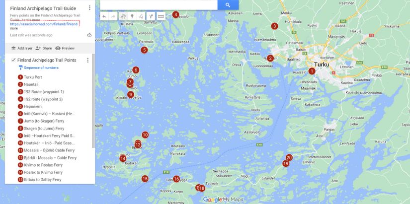
Route Map of the Finland Archipelago
We put waypoints into Google Maps to show where we’d get the ferries to and from on this route, as we found the maps provided by Visit Pargas difficult to understand. You can download their digital brochures here.
I mean, if you just take a look at Google Maps and try and figure out where the route is, it’s pretty difficult. There are, after all, more than 40,000 islets and islands here. Additionally, the Finferries timetable seems to sometimes reference the name of the island and sometimes the name of the port area. I’ve included our map here with our waypoints.
Driving Conditions on the Archipelago Trail in Finland
We traveled this route in mid-June when the days were endless, so it wasn’t a worry about getting dark early (or at all!), the roads were extremely quiet. The ferries were for the most part, pretty empty and we had no problems at all getting on them, but that might be different in the high summer season. There are speed limits, there are speed cameras everywhere. If you are driving to catch a timetable ferry, then there is NO way to make up lost time. Slow down, and enjoy the landscape. Catch the next ferry.
Using the Ferries of the Finland Archipelago
All but one of the ferries on the Finland Archipelago Trail are free. They’re generally known as the Yellow Ferries and they’re run by Finferries. The Finferries timetable and conditions of use are here. However, that’s ALL the ferries. So I’ll cover the specific ferries used for the trail in detail.
The shorter ferries on this trail are chain ferries, and they run on demand. The longer ferries run to a timetable. And yes, they run on time and strictly so. You can’t pre-book ANY of the ferries. There is a strict lineup plan. Locals and cargo get special lanes and load and unload first. There are also specific rules for cyclists joining and leaving the ferries.
So you’ll turn up, join the line, and wait to board, even for the timetabled ferries. For the timetabled ferries you’ll want to make sure you catch them, otherwise, you’ll be waiting perhaps 2 hours until the next one. On the longer ferries, there are indoor areas, some with a café, toilets, and seating areas.
There are specific rules for using the ferries of the archipelago.
Using the Archipelago Ferries: At the Ferry Harbor
There are multiple lines, and as a tourist, you should drive in the right-hand lane at stay on the right side when you stop. Certain vehicles (cargo and locals) have the right of way, so if you stay right it means that they can skip the line easily. Motorbikes are NOT allowed to skip the line. Turn your engine and lights off. Cyclists and foot passengers board and leave AFTER motor vehicles. Several of the ferries have traffic lights, so just follow them.

For many of the islands, there’s no specific “parking lot” for the ferries, you simply wait on the right-hand side of the road. As you drive up towards the ferry harbor you’ll start to see signs warning that it’s close. Do NOT speed, there could be a line of vehicles sooner than you expect!

Boarding the Ferries of the Finnish Archipelago
You can only board when directed by the ferry staff when the traffic lights indicate so, or when the barrier booms have been lifted. You’ll be directed to where to drive and park on the ferry. When on board the ferry you must engage the parking brake, and turn off your lights and engine. Motorbikes are usually parked in a specific area, but just follow instructions.
On board the Ferries of the Finnish Archipelago
There’s no smoking on the ferries, even in vehicles, although some ferries may have a designed smoking area. On the longer ferries, there are indoor areas and also seating areas. Some ferries may have cafes and toilets, but also for the longer ferries, there is usually a toilet in the area where you wait.

Exiting the Ferries of the Finnish Archipelago
You’ll usually leave the ferry in the same order that you boarded, but again, follow instructions. Foot passengers and cyclists wait until motor vehicles have departed.
Driving the Finland Archipelago Trail Anti-Clockwise
We chose to drive the archipelago trail in an anti-clockwise direction primarily because of the timetable of the Houtskär-Iniö ferry. This ferry only runs 5 times a day. If you miss it, then you’ll be waiting around two hours, or worse (for us) until the morning for the next ferry. We had also arrived overnight on the Stockholm to Turku ferry early and were keen to get started so we headed to Naantali, one of the best small summer towns in Finland.
Turku to Naantali on the Archipelago Trail
Technically we went off course right from the start, but that’s because we wanted to explore Naantali, as we figured that at the end of the trail, we’d simply want to head to our accommodation in Turku. It’s just 15 kilometers (9.3 miles) from Turku to Naantali, and we drove here straight from the Turku ferry terminal using Route 185 and the E15 roads. It took just 20 minutes. Our ferry arrived early and we were driving off the ferry at 07:45. Finland is an hour ahead of Sweden, so we’d already lost an hour on the day!
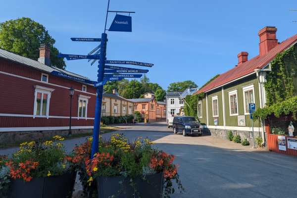
The Town of Naantali
As well as being the start or end point of the archipelago trail, Naantali is renowned as one of the best summer towns in Finland and also for being home to Moomin World. Based on the books of the beloved Finnish writer, Tove Jansson, Moomin World is found on the island of Kailo, near Naantali. The Moomins – a family of white rounded trolls with large snouts, but resembling hippopotamus are Finland’s most famous export. Jansson released 9 books between 1945 and 1993 but there are numerous TV series, films, and this theme park, Moomin World here in Naantali.
Naantali is a delight to explore. There are quaint, wooden houses on the waterfront and we also stopped off for the makings of a picnic for our day out on the archipelago trail.
Naantali to Kustavi (Heponiemi)
We left Naantali heading towards Kustavi. It’s an easy drive on rural roads then on route 192, through Taivassalo, then turning off onto the 192 (it’s signposted) towards the Kustavi (Heponiemi) – Iniö Ferry. You don’t start to see the sea until about this point. This part of the drive was our first experience of the bridges that connect some of the many islands that you’ll travel across on the archipelago trail.

There is a timetable for this ferry and you can find the most up-to-date timetable here. Rather typically, as we left Naantali we realized that we were going to just miss a ferry, but there’s no way to make up time here – unless you know the roads and where the speed cameras are. We didn’t. But never mind, it was a glorious day, and, as we were first in the line, we sat on the dock and ate our picnic breakfast.

There’s a portaloo here on the ferry harbor at Heponiemi and at each ferry harbor, there’s a map of the archipelago and not much else.
(Heponiemi) Kustavi to (Kannvik) Iniö Ferry
Yippee! Our first sighting of the Yellow Ferries of the Archipelago Trail. And such a glorious day to be traveling on this route. There was plenty of room on the ferry, but again we were first in the regular line. Our ferry left Kustavi at 11:45 and arrived on the island of Iniö 25 minutes later at the ferry harbor of Kannvik.

This is a free ferry on the route. And you’ll want to get out of the car, go up to the higher deck, and take a look at the views. They are spectacular.
Jumo
It’s just a 5-minute, 4-kilometer (2.5 mile) drive across this island to your next ferry, which is the Jumo to Skagen Ferry. You can’t get lost. There’s only one road, just follow the signs to the next ferry.
Jumo – Skagen Ferry
This ferry is another of the free ferries on the archipelago trail, and it operates on demand. Line up on the right, and then follow the traffic lights for boarding. The traffic lights indicate which lane to fill up. It’s all really rather good fun!
The Jumo to Skagen ferry takes just five minutes if that, and everyone just remains in their vehicles for this ferry.
Driving from Skagen to Dalan
It’s a slightly longer drive across this island, 6 minutes rather than 5, and as we’re driving basically across the middle of the island there are no seashore views until we get to the waiting line for the MS Antonio Ferry, which is the only ferry on this route that you have to pay for.
Mind you we did get to see some of the glorious spring lupins. And stunning as they may be, these are actually an invasive species in Finland. These stunning spring flowers seem to be part of springtime in Finland, but they’re native to the mountains of the Western states of the USA and were imported during the 19th century as an ornamental plant. While lupins appear in different colors they turn blue over time.

They’re a large plant that puts native plants literally into the shade, and as they’re much better adapted at dealing with dry periods and using the nitrogen in the soil they take over to the detriment of native species. So yes, they’re glorious and pretty, but not necessarily good for Finland.
The Iniö-Houtskär Ferry (aka the Houtskär-Iniö ferry)
This ferry is the only one on the archipelago trail that has a cost (and you can pay via credit card). The cost of the Houtskär-Iniö ferry in 2023 was 42 euros per car (including passengers). Foot passengers pay 10 Euros. You cannot book this ferry, it’s like the others on the archipelago trail, you simply arrive, wait your turn, and then board. You’ll pay the staff.

The ferry is the MS Antonia and the timetable of the Houtskär-Iniö is as follows and this timetable is valid from 12th May until 3rd September.
Iniö to Houtskär Timetable Monday to Saturday
- 11:15
- 13:15
- 15:15
- 17:45
- 20:00* (only in July)
Iniö to Houtskär Timetable Sunday
- 10:15
- 13:15
- 15:15
- 16:15
- 20:00* (only in July)
Houtskär to Iniö Timetable Monday to Saturday
- 09:15
- 12:15
- 14:15
- 16:15
- 18:45* (only in July)
Houtskär to Iniö Timetable Sunday
- 09:15
- 11:45
- 14:15
- 16:15
- 18:45* (only in July)
Two different ferries depart from this ferry harbor, so just make sure you’re in the correct line otherwise you’ll end up in Keistiö.
The MS Antonio takes about an hour to run this route, and there’s a small café onboard, which may or may not be fully open depending on when you travel. There was only coffee available when we traveled in mid-June, but to be fair the ferry was pretty empty.
Mossala Island
You’ll arrive on Mossala Island after about an hour, and again it’s just a short hop across the island to your next ferry, 5 minutes, 3 kilometers (1.9 miles) before you arrive at the next ferry, which might just be the shortest ferry crossing on the archipelago trail.
The Mossala E – Björkö Cable Ferry
This ferry, which takes about 2 minutes – it’s probably longer to load it than it takes to cross this patch of water – is also free and operates on demand.
Björkö and Kivimo Islands
These two islands are joined by a bridge, and again the road is primarily in the middle of the islands, so you’ll get landscape views, but no real sea views.
The Kivimo to Roslax Ferry
The ferry from Kivimo to Roslax is another ferry that runs on demand and again it’s very quick.
Roslax to Kittiius
If you drive straight across you’ll get to spend a whopping 16 minutes on this part of the route. We drove across stopping briefly only for photos and stopped at the Kittius ferry harbour. There’s a café here, accommodation, and a portaloo in the ferry harbor area. It’s a perfect place for a picnic on the rocks overlooking the water.

The Kittuis to Galtby Ferry
This was the biggest ferry on the archipelago trail for us and we were joined by a logging truck, as well as several other cars, cyclists, and motorcyclists, but there was still plenty of room on the ferry. There’s a decent-sized café on this ferry, with some great snacks and coffee and big picture windows to watch the world slip by through for the 30 minutes that the ferry takes. There are also toilets onboard. The ferry takes cards or cash for payment in the café.

This ferry (operates on a timetable, which you can see here.)
Galtby to Korpo (Retais)
If you don’t stop on any of these islands it’s a quick drive, from Galtby to Korpo it’s just 8 minutes to drive the 6.8 kilometers (4.2 miles) to the next ferry harbor, which is Korpo Retais. If you do want to stop, then the church of St Michael is one of Finland’s oldest.
The Retais – Pärnäs Ferry
The Retais – Pärnäs Ferry operates on demand and takes just 5 minutes to deliver you to your next island. They come up thick and fast, but it’s going to come to an end soon – this is the second to last ferry on the archipelago trail.
Pärnäs to Nagu / Naavu and Prostvik
Driving across this island takes about 13 minutes, and you’ll end up in the village or Naavu/Nagu (depending on the spelling/translation). If you’re looking for somewhere to stay in the Archipelago that has services, then this is a good option. The 3-star Hotel Strandbo is right on the harborfront and puts you in a good place to explore on foot – it won’t take long, but there are good options for food and drink here.
If you don’t plan to stay, then drive on a further 20 minutes to your final ferry of the archipelago trail, the Nagu—Pargas ferry
The Nagu to Pargas Ferry (aka the Prostvik – Lillmälö Ferry)
This last ferry on the archipelago trail takes just 15 minutes and is a large ferry again.

Pargas to Turku
While this last stretch of the archipelago trail is picturesque, it’s also busier, you feel like you’re back in the real world, it takes about 45 minutes to drive from getting off the last ferry to the center of Turku.
Map of the Finland Archipelago Trail
Here’s the map of the ferry harbor and stops on the Finland Archipelago Trail. I’ve included the map from the Visit Pargas folks, as well our google map with all the way points on.
Map from Visit Pargas of the Archipelago Trail

Our Map of the Route for the Archipelago Trail
You can also see the full map here.
FAQS about the Finland Archipelago Trail
Here’s some more useful information about driving or cycling the Archipelago Trail.
When can you do the archipelago trail in Finland?
The trail (and the ferries) are open fully from late spring to mid-fall each year. The dates differ slightly each year, but for 2024, the archipelago trail is fully open from 10th May 2024 until the 8th September 2024.
Where does the Archipelago Trail start and finish?
The archipelago trail starts in Turku and ends in Naantali, officially. But you can drive it in either direction. (don’t forget to re-read why we chose to drive it in an anti-clockwise direction).
Travel Tips for Finland
- Get Travel Insurance: Civitatis includes medical expenses, repatriation, theft, luggage delays. No deductibles or upfront payments. Get a quote here.
- Get online immediately with an eSIM in Finland – one SIM for the whole world, data never expires.
- Rent a car to explore Finland with Discover Cars
- Get your Finnish airport transfer here with Welcome Pickups.
- Book the best tours, attractions and guides on Get Your Guide and Viator
- Save money in Finland with a Wise debit card
- Book accommodation in Finland with Booking
Final Words on Driving the Archipelago Trail
Even if you have just one day it’s worth taking the time to drive the Finland Archipelago Trail, the 200 kilometers of roads and 50 kilometers of ferry transport are a glorious introduction to this lovely part of southwest Finland. Take a picnic, slow down and explore, and consider going anti-clockwise to avoid ferry lines too!
ASocialNomad is a participant in the Amazon Services LLC Associates Program, an affiliate advertising program designed to provide a means for sites to earn advertising fees by advertising and linking to amazon.com, amazon.co.uk, and amazon.ca. Amazon and the Amazon logo are trademarks of Amazon.com, Inc. or its affiliates. As an Amazon Associate, I earn from qualifying purchases.
6 thoughts on “Driving the Finland Archipelago Trail Guide [A day trip from Turku]”
Stunning explanation and photos Sarah – it was incredibly helpful.
Hugely appreciated how much time and effort you put into this.
Amazing!
I will be doing the same anticlockwise route as you in July. I cant wait 🙂
Thank you and all the very best wishes to you and Nigel 🙂
Brendan
Hey Brendan, thanks so much for the comments, it truly is a glorious drive. Hope you enjoy it as much as we did! Sarah
Hi Sarah, thanks for your explanation and tips! How long did it take for you to do the whole trail and how frequently did you stop? We’re going to Turku in 3 weeks and really want to see as much as possible from the archipelago. But we’re traveling with 2 kids, so I’m sorting out what will be manageable.
Thanks,
Sam
Hi Sam – we arrived on the overnight ferry from Stockholm, and set off from there – via a trip to Lidl for a picnic. We also spent about 45 minutes in Naantali before we set off. So left Naantali at 0910, arrived back into Turku at about 1800. We missed our first ferry, so had about an hour there waiting for the next one. Stops, we stopped for photos, and for lunch, plus the obligatory waits for ferries. So not huge amount of stops, but also didn’t feel like we were manically driving, it was a pleasant pace. The longer ferries give you a break from driving. Hope this helps!
Bonjour Sarah,
Une question : nous comptons consacrer 2 jours a l archipelago trail. Sur quelle ile dormir d’apres vous ?
Hello! I woud opt for Inio – there are several places to stay there, and you should have some good options. http://visitinio.fi/ Let me know how you get on!