Our route today takes us from here at the hot springs at Bibi Fatima to Bulunkul Lake. It’s a drive of 170 kilometers (105 miles), with most of the route in the Wahkan Valley, although we will traverse a little of the actual Pamir Highway before going off-road again to reach the lake and village of Bulunkul. We head back down the valley from the hot springs. We’re aiming for Tajikistan’s coldest village tonight, but en route we’re also heading to see a solar calendar, a museum of Tajik living arrangements, a Pamiri Sufi, and the petroglyphs of Langar. This is Day 5 of our 7-day Pamir Highway journey from Dushanbe to Osh, and today the landscapes change yet again.
THIS POST MAY CONTAIN COMPENSATED AND AFFILIATE LINKS MORE INFORMATION IN OUR DISCLAIMER
We’re leaving the Wakhan Valley behind and climbing onto the high Pamir plateau. It’s stark, wind-swept, and the vegetation disappears. Austere and dramatic are the descriptors that spring to mind. If you want the full route overview first, you can read my 7-day Pamir Highway itinerary here.
PRACTICAL TRAVEL TIPS
- 🛡️ Get Travel Insurance: Civitatis includes medical expenses, repatriation, theft, luggage delays. No deductibles or upfront payments. Get a quote here.
- 💰 Read about cash, ATMS and paying for things in Tajikistan
- 🔌 Check out the Tajik plug, socket & power situation. Buy this adapter.
- 📶 Get online EASILY & cheaply – One eSim for the world. Data never expires
Quick Overview of the Route and Statistics
Start: Bibi Fatima (Wakhan Valley)
End: Bulunkul Lake
- Distance: Approximately 170 kilometers (105 miles)
- Driving time: 7-8 hours, including stops
- Starting altitude: 3,200 meters (10,498 feet)
- Highest altitude today: Around 4,300 meters (14,108 feet)
- Overnight altitude: 3,700 meters (12,139 feet)
- Costs: Dinner b&b at bulunkul lake 220 TJS per person, shop at bulunkul lake 10 = noodles and cookies.
- Road conditions: Mixed paved and rough sections; increasingly remote
- Overnight location: Homestay in Bulunkul village
If you missed yesterday, then my guide to day 4 on the Pamir Highway is here.
Day 5 – Pamir Highway, What to Expect
Our route today takes us from here at the Bibi Fatima Hot Springs to Bulunkul Lake. It’s a drive of 170 kilometers, with most of the route in the Wahkan Valley, although we will traverse a little of the actual Pamir Highway before going off-road again to reach the lake and village of Bulunkul.
We head back down the valley from the hot springs. We’re aiming for Tajikistan’s coldest village tonight, but en route we’re also heading to see a solar calendar, a museum of Tajik living arrangements, a Pamiri Sufi, and the petroglyphs of Langar.
Today, the scenery becomes more open, more barren, and more dramatic. There’s little vegetation, lots of rocks, sand, and sky. And a whole lot of altitude too, and we’ve got some hiking to do as well, which is tough, more because the trail isn’t really a trail, but a rock face, and yeah, the breathing is tough too.
There’s a valley and all the harvesting that goes on there, animals being moved along the road. Motorcyclists and river crossings, too, before we hear sounds of gunfire from across the river in Afghanistan, and there’s a downed power line before we arrive in Tajikistan’s coldest village.
Pamir Highway Day 5: Costs
- Dinner b&b at bulunkul lake 220 TJS per person
- Shop at bulunkul lake 10 = noodles and cookies.
Pamir Highway Day 5: Road Conditions & Driving Reality
The road conditions today vary, but none of them are particularly good. The road back down from Bibi Fatima Hot Springs was paved and good, and the road through the valley was also good. However, as we tracked upwards, the road included a diversion (rockfall had blocked the road leading to a bridge, which was out). The diversion was rough, loose rocks and shale – so bad that we got stuck behind a group of motorcyclists having to push each other up the hill.
And then there was a river crossing – that bridge that was out meant that it was a slightly longer diversion and a really rough river crossing. The road is mostly gravel today, although we switch back onto a paved (tarmac section, which has buckled with the heat from summer and heavy trucks. It’s not for the fainthearted, and we’re infinitely grateful for Habib’s driving skills!
Pamir Highway Day 5: Key Stops along the Way
There are a variety of stops that you can make on this route today, from Bibi Fatima Hot Springs. If you didn’t get to Yamchun Fortress on your way in, then stop on the way down. There’s more about Yamchun Fortress here. Then there’s Sufi Muborak-Kadami Vakhani’s museum, a stone calendar and clock, a Buddhist Stupa in Vrang, and petroglyphs in Langar. Here’s what we chose to stop at.
The Stone Calendar of Muborak Wakhoni in Yamg
The solar / stone calendar was originally created to measure the first day of Spring – Navruz. Navruz is one of the Persian people’s biggest holidays, and that also goes for Tajiks. The word comes from «nav» (nay, nav), new, and «ruz» (ruch, ruz)- day. If you’re traveling in this region, you’ll hear and see it spelled and pronounced the same but differently. Perhaps Novruz, Naviyz (Arabs), Navruz (Persians and Tajiks), Nauryz (Kazakhs and Kyrgyzs). It’s celebrated differently in all these cultures, but essentially it’s the first day of what we’d consider Spring, when nature revives after winter. The hole in the stone lines up with the setting sun on March 21st each year.
The calendar was created here by Muborak Wakhoni (1833-1903). He was a mystic poet, musician, astronomer, and Ismaili religious scholar.
The Khona- Osorhonai Muboraki Vakhoni Sufi Museum
Near the stone calendar, there’s a small museum dedicated to him and also to Tajik houses, where we learn how, in a single room, the living quarters were arranged, and what all the carving on the wood inside the stunning Tajik ceilings means. It’s his grandson who is the curator of the museum. As well as the traditional living area, there are traditional clothes and hats here. Of course, we are all convinced to don one for a photo.
We leave and head back down to the main road through the valley. Harvesting is definitely going on as we continue through the valley. The river is wide here, and we can see glaciers on the Afghan side. We’re seeing increasing numbers of animals driven down, heading for lower ground. Today’s highlight is a donkey with a pack, in which it carries a baby goat. The herder reminds us of the realities of life when he sees us taking a photo, pulling a finger across his throat. Dinner, later, we suspect. 10 minutes later, a donkey has a very contented sheep cadging a ride.
The Petroglyphs of Langar
Our next stop is in Langar, where Habib lets us climb up the steep “paths” towards the more than 6000 petroglyphs. It’s hard work – We’re at about 3,000 meters. It’s hot. We walk through two cemeteries on the way up. And then when we get there, it’s hard to tell what’s a legitimate petroglyph and what’s more recent graffiti. Hard to deny that the views from up here are spectacular, though.
We make a quick stop where there are stunning views over the border river to Afghanistan, and hear shots being fired. It’s not clear who is firing. Or what. But there doesn’t seem to be any action.
We catch up with some of the Russian motorcyclists. There’s a diversion on this part of the road (a bridge is out), and it involves quite a lot of loose gravel/shale. The act of getting the bikes up the gravel takes one riding, and three pushing and shoving the bikes up. I don’t think I’m alone in saying a few whispered words of thanks for Habib’s Land Cruiser. There’s also an old truck trying to come in the opposite direction, so we’re stuck for a short while until all 4 bikes make it up the hill, down the other side, and the truck comes through.
The bikes get through, and we catch them in a few minutes. They need to get across the river (remember the bridge is out), and so it’s the same process. One rides, two push/pull/hold it up, one holds the Go Pro…. Habib motors on through with nary a worry.
The landscape now is whatever the word is for monochrome, but just brown, with small patches of vibrant green, bright blue, and white where there’s water. We stop by an old Russian UAZ that’s broken down. Habib chats, they’re fine, it seems, it’s under control, and we continue. There’s white alongside the road, and near the river. It’s salt. Not snow. Not yet. It’s not harvested for human consumption, but the animals do consume it.
And now the roads are like Mongolia. Barely there. Tracks in all directions, but nothing really what you’d call a road. We pass a guy from Austria in a Volkswagen Caddy and catch up with the group of 8 or 9 jeeps with Chinese visitors. They’re fancy travelers. They have a toilet tent. Meanwhile, I’m holding on, and the boys walk 30 feet from the Land Cruiser and avail themselves of the facilities.
We briefly make it onto the Pamir Highway again (we’ve been in the Wahkan Valley, not on the Highway), and then head off towards Bulunkul Lake. We’re almost there, then Habib slides to a halt. There’s a downed power line across the road. We don’t spot it. Of course, we don’t; he’s an amazing driver. He checks it’s not live, and makes it safe for other drivers, and then we’re there. In the coldest villages in Tajikistan. Bulunkul. It was recorded as -63 C.
There’s a freshwater lake, a village of 306 people. They live here year-round. There’s a school, a small shop, and a recent addition. There’s a small solar field here. But it’s not quite working at the moment. And so we get only 3 hours of electricity tonight. That coincides with when we’re in the homestay dining room, and so we’ve forgotten to plug our phones in. Ack.
We did have a shower. Of sorts. There’s hot water from a dung-powered stove. And there’s a cup to pour the water over your head. It works for me. There are two toilets as well. With the best toilet paper since Europe. Although the water goes off overnight, and there seem to be several people staying who’ve got, shall we say, gastro problems.
There’s another group staying at this homestay; they’re with Cory, a Belgian driver of a reconditioned Orange Russian UAZ. We’d seen his website, but his trip was full for our dates. He has four Koreans, a Brit, and a Swiss guy as his guests. You can book a trip with Cory here.
It’s another early night. Robert, Nigel, and I have a room with four beds. Vladimir is next door. Habib is next door to Vladimir, and there’s another cat. Only this one is attached to the outside of the Yurt outside. This might be the coldest village in Central Asia, but it’s cosy inside.
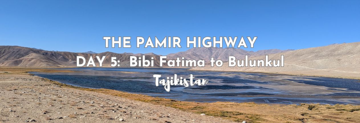
Bulunkul Lake
Bulunkul Lake sits at around 3,700 meters (12,139 feet) and is one of the highest permanent settlements along the Pamir Highway. We’re stopping at Bulunkul Village for the night, but took a short stop at a viewpoint over the lake before we got to the village.
Pamir Highway Day 5: Altitude Notes
Today is the biggest altitude shift so far. We left Bibi Fatima Hot Springs at 3,200 meters (10,498 feet), did some hiking at around 3,000 meters, then drove up to around 4,300 meters (14,108 feet), and we’re sleeping at 3,700 meters (12,139 feet) at Bulunkul.
My guide to altitude on the Pamir is here. I’ve got a mild headache, and just keeping drinking tea and water. I’m also not particularly interested in dinner, which is fried fish from the lake, but I soldier on and continue with the bread.
Pamir Highway Day 5: Accommodation
Accommodation in Bulunkul village is very simple. There are homestays run by local families. Habib knows them well and is helping serve up dinner. There are dorm-style sleeping arrangements, although there is plenty of room for everyone who is here. Electricity goes off while we are at dinner, and won’t come on again until after we leave. Always be charging is the motto here. In case there’s no electricity later. Which there isn’t
The toilets (there are two of them) are shared and outside in a separate building. There’s a single shower in that building, it’s hot and heated by a dung stove. Bulunkul is the coldest inhabited place in Central Asia, and even in summer, the nights can be cold, as they were in September. You need layers here!
Ready for the next day? That’s here. Day 6 on the Pamir Highway.
TAJIKISTAN TRAVEL RESOURCES
AIRPORT TRANSFERS
24/7 pickup & drop off. Trusted, local English speaking drivers. Prebook & prepay online with cards.
Book a Transfer
HOTELS AND APARTMENTS
See choices here
Double rooms?Budget rooms? Need a washing machine? The best choice of hotels & apartments.
TOURS & ATTRACTIONS
Most excursion choices, small group tours, skip-line tickets, free cancellation and top local guides.
Top options here.
PAMIR HIGHWAY
Choose routes here
Best choice of vehicles, dates, drives and routes. Book early for more options.
Final Thoughts on Day 5 of the Pamir Highway
The change in the landscape is dramatic. This morning we could see our breath. And then we saw the harvesting going on in the valley, literally a few miles before we heard gunfire across the valley and river in Afghanistan, and then the vegetation disappeared. Tonight’s village feels friendly, but bleak; there’s no vegetation at all. It’s flat. Almost featureless. And cold.
ASocialNomad is a participant in the Amazon Services LLC Associates Program, an affiliate advertising program designed to provide a means for sites to earn advertising fees by advertising and linking to amazon.com, amazon.co.uk, and amazon.ca. Amazon and the Amazon logo are trademarks of Amazon.com, Inc. or its affiliates. As an Amazon Associate, I earn from qualifying purchases.